
Hike from the parking lot of Seru Pretu snack to the most Eastern part of the former plantation of Santa Catharina and part of the Koral Tabak area. First the hike goes to the Koral Tabak Area where a presumed Indian cave can be visited. Inside is a small statue with a face. Then the hike continues to the coast to the first bay on this hike, Boka di Mangel. Then further along the coast where the border between the two areas will be crossed before two other bays are visited, Boka Grandi and Boka Labadera. Then the hike returns to the starting point via a dirt road along the former plantation house of Santa Catharina.
Highlights of this trip:
- the walk along the Northern shore
- Indian cave
- Boka di mangel
- Boka grandi
- Boka Labadera
- Plantation house Santa Catharina (optional)
This is a rather long hike over mostly flat terrain. Along the coast the underground is rather sharp because of eroded limestone. So best bring shoes with a good sturdy sole.
Parking
The car can be parked in the parking lot of the Santu Pretu snack. Be careful not to block access to the snack or the car wash.
Description of the trail
For a map of the trail check the download link below under the heading "Trail map". Also the track is available for download there.
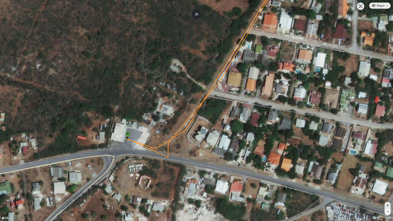 From the parking lot you need to enter a small path along a fence; to find this path look carefully at the detail map (photo) below under the Trail Map heading. The building at the left hand side is the Toko with the parking lot where the hike starts. Follow the line to find the path along the fence. Follow this small path till you reach the first houses of Santa Catharina. There you follow the dirt road straight on.
When you pass the last house of Santa Catharina along this road start looking for a dirt road to the right. Take that dirt road. From there you follow the dirt roads either with the help of the downloaded map or helped by the track in the Wikiloc or Locus Map app.
The first part of this hike is not very interesting. The area is flat and the vegetation is sparse. You could meet cows and donkeys during this first part of the hike. Be careful not to disturb the cows. You never know if they are friendly to you if disturbed. After a while you are walking over good roads, the remnants of a plan to build houses here that didn't come through. Then the path continues uphill. After a while you will see a path at your left hand side towards the indian cave. Take this if you want to visit this cave. Afterwards you come back at this path and continue in the direction of the coast.
At the coast you will be in the vicinity of the first bay of this hike, Boka di Mangel. Then continue along the coast. The former border between the two areas is marked by a low stone wall. Cross the border and continue to Boka Grandi. Before you get to that bay you pass two other small bays without a name. The first one is really small and can be compared to Boka Pistol in the Shete Boka area. The second nameless bay is a bit larger but apparently too small to get a name. Then you reach Boka Grandi and a bit further Boka Labadera. At the Eastern side of the end of the bay a path starts to the South in the direction of the plantation house. Take that path.
If you like you can visit the plantation house. It is in a bad state so be careful when you enter the building.
Along the road at the right hand side are the remains of a small building next to a water tank. It looks as if here a pump was located to distribute the water. There are more water tanks on both sides of the road.
Follow the road till you reach once again the small path along the fence. Take that to return to your car.
Track of this hike on Wikiloc
Link to the track of this hike on Wikiloc (opens in a new window).
The track can be downloaded but a better option is to install the Wikiloc app on your smartphone; when you click on the download link with the app installed on your phone the link opens in Wikiloc (can take some time) and you are able to follow the track.
It appears that this only works for the paid Premium version of this app.
As an alternative the free version of the Locus Map can be used. To use this app you need to download the track in GPX-format either from Wikiloc or directly from this page (see below under "Trail map").
Location
Pictures
 Former entrance of plantation Santa Catharina
 Cattle along the trail
 Plantation house Koral Tabak
 Indian cave
 Statue with face
 Indian cave
 View from the indian cave
 Close to the shore the landscape changes
 Boka di mangel
 Rough seas along the Northern shore
 Small and larger snails
 The former border wall
 Nameless bay
 Boka Grandi
 Boka Labadera
 Water tank
 Deep well but dry


Trail map (download)
Map with route; right click and Save As GPS track Visit Website